 Catalogo de metadatos del IGME
Geological Map
Type of resources
Available actions
Topics
Provided by
Formats
Representation types
Update frequencies
Service types
Scale
-
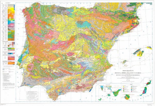
Geological map of the Iberian Peninsula, Balearic and Canary Islands at 1M scale. It includes the chronolithostratigraphic units and the representation of the tectonic structure by means of faults and thrusts.
-
Servicio de visualización del nuevo Mapa Geológico de España y Portugal a escala 1:1 000 000 publicado en 2015. Se trata de la versión más actualizada de la cartografía geológica de la Península Ibérica, así como de Ceuta y Melilla y de todo el territorio insular de España y Portugal: Baleares, Canarias, Azores y Madeira. Esta versión incluye por primera vez la cartografía geológica de la plataforma continental de ambos países y de las islas del Atlántico. Este mapa recoge todo el conocimiento geológico aportado por la realización de la serie MAGNA de cartografía geológica a escala 1:50 0000 del IGME, para el territorio español, y la cartografía geológica sistemática del territorio de Portugal realizada por la LNEG. La parte continental del mapa se ha realizado a partir de los anteriores resúmenes a escala 1:400.000 elaborados para cada una de las principales unidades geológicas de España, a saber, el Macizo del Varisco, los Pirineos, la Cordillera Bética, la Cordillera Cantábrica e Ibérica y las cuencas del Duero, el Tajo y el Ebro, y la cartografía geológica a escala 1:200.000 realizada en Portugal.
-
Geological map of Spain and Portugal at scale 1:1 000 000 of 2015 is an updated cartographic version of the Iberian Peninsula as well as Ceuta and Melilla and all the insular territory of Spain and Portugal: Balearic Islands, Canary Islands, Azores and Madeira, published periodically by the IGME in collaboration with the Geological Survey of Portugal (LNEG). This new version includes for the first time the geological cartography of the continental shelf and the Atlantic islands of Portugal. This map includes all the new geological knowledge that has resulted from the completion of the MAGNA series of 1:50,000 scale geological cartography of the IGME for the Spanish territory and the systematic series of cartography of the Portuguese territory developed by the LNEG. The continental part of the map has been composed from previous syntheses at a scale of 1:400,000 developed for each major geological unit in Spain, specifically, the Variscan Massif, the Pyrenees, the Baetic, Cantabrian and Iberian C. and the Cenozoic Basins of the Duero, Tagus and Ebro, and from the geological cartography at a scale of 1:200,000 produced in Portugal.